Amsterdam
Canals

  • Jan 10, 2020
  • Adriaan and Dion
  • Predictive Maintenance

In January 2020 Sonarski made one of its first official attempts to test and show what our SLAM algorithm is capable of. For this, we decided to take a trip down the Amsterdam Canals by boat, to map a small part of its waterways. This test would prove to provide insight on our loop closure (e.g. scanning a pre-determined path in a circle to see if the start and end of the track align) and overall scan accuracy.

Blog Images

We used the LiDAR backpack, a drone, and a GoPro to secure some footage for our video. The drone turned out to be perfect for getting stabilized footage due to its gimbal camera. We recorded video with the drone in hand as we couldn`t go airborne (the city rules restrict flying). The GoPro was mounted under the LiDAR with a front and back-facing camera.

Only a couple of minutes of scanning can already produce millions of points once the SLAM algorithm produces the point cloud.

We rented a boat with a crew of 3 and made our way onto the canals. Winter turned out to be a perfect time for our scanning process as there were almost no other boats sailing the water and we had a rather quiet day on the streets surrounding us. At the time our algorithm had a difficult time filtering moving objects out of our point cloud, so the fewer moving objects (boats, people, bikers, etc), the better.

BLog ImagesAbove, part of the Amsterdam Canals point cloud.

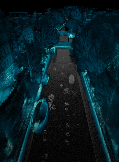
It took us some time to do our fully planned route, but we were done in under two hours. We wanted to scan as much as possible so we could cherry-pick different sections and see if we had a correct loop closure. The loop closure test was done by going in a circle on the canal and trying to make our starting point align with our endpoint as close as possible.

With our scanning complete, we needed to process the data. One problem we had to face was the processing of a huge amount of data. Only a couple of minutes of scanning can already produce millions of points once the SLAM algorithm produces the point cloud. We had huge scans of 20 to 30 minutes at the time. Therefore, we decided to process the data in parts and picked our best parts of these scans for further processing. The results varied. At times the algorithm would create a skewed point cloud without there being motion in our scan, and sometimes the point cloud would look fuzzy or glitched. Overall, the test was a success and provided us the information we needed to further perfect our algorithm.

To give a small taste of what the future might hold in our LiDAR research we created a mock-up video that shows the power of the SLAM algorithm in combination with sonar. The video below shows our scanned canals in combination with an underwater point cloud. To create the underwater point cloud, we simply modeled the underwater view in 3D and converted it into points. The underwater point cloud was then matched with our scan and merged into one.

Blog Images